Blank Map of Georgia (Counties)
Printable map of Georgia with all 159 counties, in four versions — blank, labeled, colored and with cities. Download as SVG, PNG or PDF. Public-domain data, no watermark.
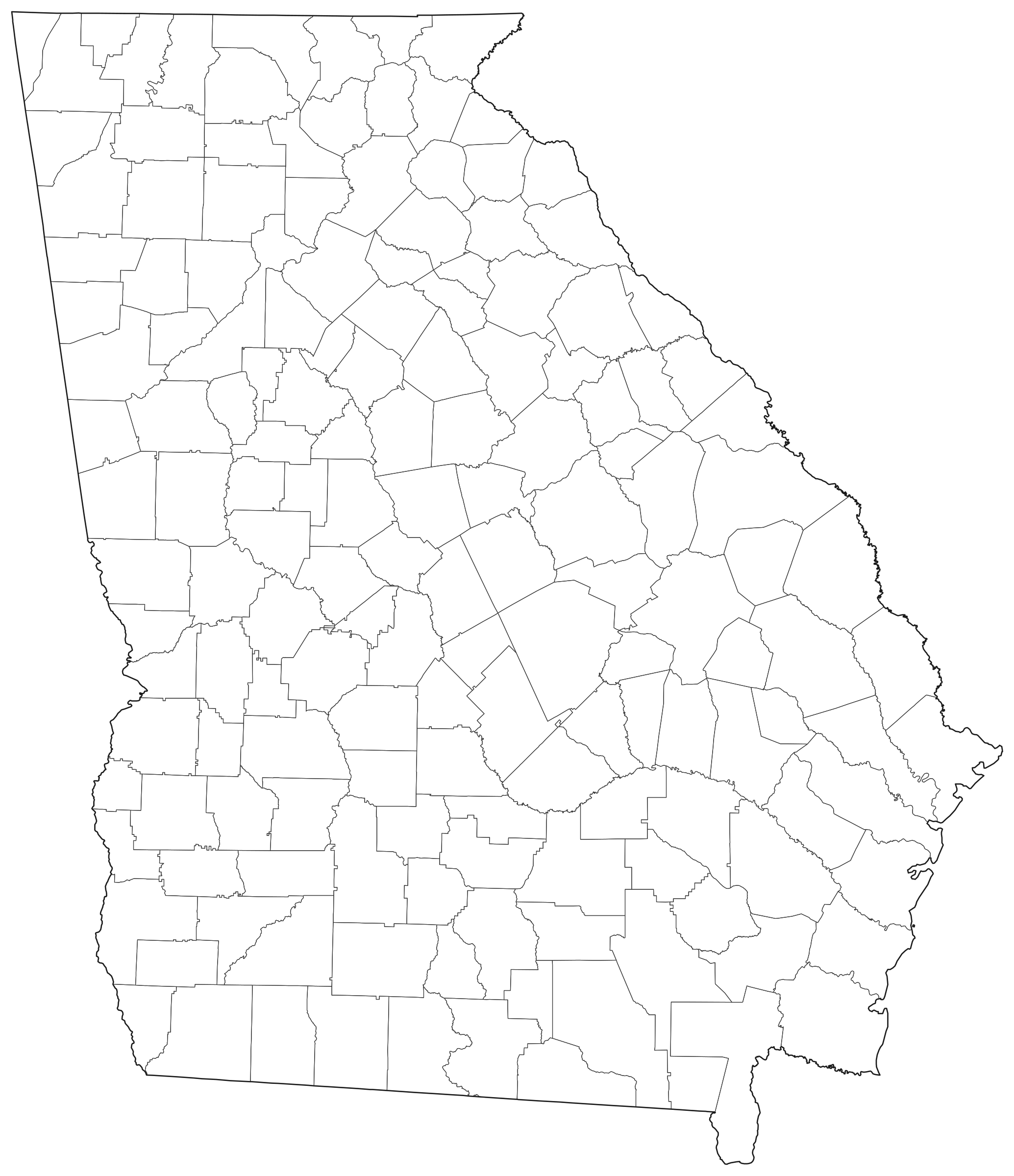
Outlines only — no labels, no fill.
SVG (vector)
Any size, editable in Inkscape, Illustrator or Figma.
PNG and PDF files are drawn in your browser at the size you pick; nothing is uploaded. No watermark, no sign-up.
Georgia at a glance
| Counties on the map | 159 |
| Land area (sum of the shapes) | 149,490 km² · 57,718 mi² |
| Largest county by land area | Ware County — 2,329 km² |
| Smallest county by land area | Clarke County — 309 km² |
| Population (ACS 2019–2023) | 10,822,590 |
| Most populous county | Fulton County — 1,068,507 |
| Places on the with-cities version | Atlanta, Columbus, Augusta-Richmond County, Macon-Bibb County, Savannah, Athens-Clarke County, South Fulton, Sandy Springs, Roswell, Johns Creek |
Land areas are the Census Bureau's ALAND figures. Population and income are American Community Survey 5-year estimates, which carry margins of error. Cities are the largest Census places by ACS population; a crowded label is left off rather than overlapped.
All 159 counties of Georgia
| County | Land area, km² | Land area, mi² | Population | Median household income |
|---|---|---|---|---|
| Appling County | 1,316 | 508 | 18,426 | $43,728 |
| Atkinson County | 888 | 343 | 8,261 | $38,438 |
| Bacon County | 736 | 284 | 11,129 | $50,310 |
| Baker County | 886 | 342 | 2,830 | $44,405 |
| Baldwin County | 670 | 259 | 43,669 | $55,413 |
| Banks County | 603 | 233 | 18,757 | $68,830 |
| Barrow County | 417 | 161 | 86,982 | $77,477 |
| Bartow County | 1,189 | 459 | 111,153 | $79,431 |
| Ben Hill County | 648 | 250 | 17,138 | $39,081 |
| Berrien County | 1,174 | 453 | 18,257 | $50,414 |
| Bibb County | 646 | 249 | 156,543 | $50,747 |
| Bleckley County | 559 | 216 | 12,414 | $53,005 |
| Brantley County | 1,148 | 443 | 18,171 | $47,801 |
| Brooks County | 1,277 | 493 | 16,285 | $47,656 |
| Bryan County | 1,133 | 437 | 46,681 | $94,234 |
| Bulloch County | 1,751 | 676 | 81,372 | $56,832 |
| Burke County | 2,142 | 827 | 24,427 | $50,739 |
| Butts County | 476 | 184 | 26,074 | $59,221 |
| Calhoun County | 726 | 280 | 5,528 | $55,714 |
| Camden County | 1,632 | 630 | 56,036 | $72,399 |
| Candler County | 630 | 243 | 10,972 | $50,431 |
| Carroll County | 1,293 | 499 | 122,187 | $72,327 |
| Catoosa County | 420 | 162 | 68,356 | $72,425 |
| Charlton County | 2,020 | 780 | 12,711 | $48,534 |
| Chatham County | 1,121 | 433 | 298,143 | $69,575 |
| Chattahoochee County | 644 | 249 | 9,181 | $59,221 |
| Chattooga County | 812 | 314 | 24,975 | $47,785 |
| Cherokee County | 1,090 | 421 | 274,539 | $105,442 |
| Clarke County | 309 | 119 | 129,267 | $52,267 |
| Clay County | 506 | 195 | 2,853 | $48,715 |
| Clayton County | 367 | 142 | 298,771 | $58,507 |
| Clinch County | 2,111 | 815 | 6,722 | $55,549 |
| Cobb County | 880 | 340 | 769,152 | $98,712 |
| Coffee County | 1,534 | 592 | 43,161 | $50,175 |
| Colquitt County | 1,417 | 547 | 45,907 | $49,691 |
| Columbia County | 752 | 290 | 159,638 | $96,122 |
| Cook County | 592 | 229 | 17,363 | $50,133 |
| Coweta County | 1,142 | 441 | 150,071 | $94,142 |
| Crawford County | 842 | 325 | 12,183 | $60,905 |
| Crisp County | 706 | 273 | 19,995 | $42,745 |
| Dade County | 451 | 174 | 16,196 | $58,936 |
| Dawson County | 546 | 211 | 28,704 | $88,986 |
| Decatur County | 1,547 | 597 | 29,118 | $50,485 |
| DeKalb County | 693 | 268 | 762,105 | $77,683 |
| Dodge County | 1,285 | 496 | 19,909 | $50,152 |
| Dooly County | 1,017 | 393 | 11,026 | $56,545 |
| Dougherty County | 851 | 329 | 83,915 | $46,784 |
| Douglas County | 518 | 200 | 146,141 | $80,764 |
| Early County | 1,328 | 513 | 10,683 | $53,750 |
| Echols County | 1,089 | 420 | 3,705 | $61,723 |
| Effingham County | 1,240 | 479 | 67,265 | $85,465 |
| Elbert County | 909 | 351 | 19,725 | $49,727 |
| Emanuel County | 1,763 | 681 | 22,961 | $50,053 |
| Evans County | 474 | 183 | 10,740 | $53,908 |
| Fannin County | 1,003 | 387 | 25,605 | $58,073 |
| Fayette County | 504 | 195 | 120,689 | $108,986 |
| Floyd County | 1,320 | 510 | 98,985 | $62,540 |
| Forsyth County | 582 | 225 | 260,062 | $138,000 |
| Franklin County | 677 | 261 | 23,840 | $52,264 |
| Fulton County | 1,364 | 527 | 1,068,507 | $91,490 |
| Gilmer County | 1,104 | 426 | 31,976 | $72,542 |
| Glascock County | 372 | 144 | 2,913 | $55,250 |
| Glynn County | 1,087 | 420 | 84,987 | $68,546 |
| Gordon County | 923 | 356 | 58,336 | $61,997 |
| Grady County | 1,177 | 454 | 26,056 | $54,312 |
| Greene County | 1,004 | 388 | 19,586 | $84,530 |
| Gwinnett County | 1,117 | 431 | 966,972 | $84,823 |
| Habersham County | 717 | 277 | 46,948 | $65,622 |
| Hall County | 1,016 | 392 | 208,395 | $77,430 |
| Hancock County | 1,220 | 471 | 8,630 | $33,182 |
| Haralson County | 731 | 282 | 30,720 | $65,016 |
| Harris County | 1,201 | 464 | 35,509 | $89,184 |
| Hart County | 602 | 232 | 26,484 | $57,241 |
| Heard County | 767 | 296 | 11,616 | $62,907 |
| Henry County | 825 | 319 | 245,417 | $81,612 |
| Houston County | 974 | 376 | 166,902 | $80,743 |
| Irwin County | 918 | 354 | 9,385 | $53,915 |
| Jackson County | 880 | 340 | 80,640 | $85,012 |
| Jasper County | 954 | 368 | 15,345 | $59,574 |
| Jeff Davis County | 857 | 331 | 14,838 | $40,879 |
| Jefferson County | 1,364 | 527 | 15,468 | $46,561 |
| Jenkins County | 900 | 347 | 8,674 | $36,906 |
| Johnson County | 785 | 303 | 9,192 | $54,183 |
| Jones County | 1,020 | 394 | 28,526 | $68,259 |
| Lamar County | 475 | 183 | 19,098 | $68,457 |
| Lanier County | 509 | 197 | 10,094 | $44,361 |
| Laurens County | 2,091 | 807 | 49,619 | $49,705 |
| Lee County | 922 | 356 | 33,337 | $88,024 |
| Liberty County | 1,338 | 517 | 66,826 | $59,013 |
| Lincoln County | 545 | 210 | 7,773 | $50,688 |
| Long County | 1,037 | 400 | 17,512 | $64,747 |
| Lowndes County | 1,288 | 497 | 119,055 | $55,887 |
| Lumpkin County | 733 | 283 | 33,931 | $72,388 |
| Macon County | 1,038 | 401 | 11,953 | $37,177 |
| Madison County | 731 | 282 | 30,914 | $58,784 |
| Marion County | 947 | 366 | 7,474 | $50,484 |
| McDuffie County | 667 | 258 | 21,687 | $54,058 |
| McIntosh County | 1,117 | 431 | 11,187 | $50,348 |
| Meriwether County | 1,297 | 501 | 20,757 | $56,458 |
| Miller County | 731 | 282 | 5,873 | $58,407 |
| Mitchell County | 1,326 | 512 | 21,441 | $51,908 |
| Monroe County | 1,026 | 396 | 28,919 | $82,863 |
| Montgomery County | 625 | 241 | 8,675 | $51,188 |
| Morgan County | 900 | 347 | 20,614 | $85,692 |
| Murray County | 892 | 344 | 40,282 | $67,880 |
| Muscogee County | 561 | 217 | 204,383 | $56,622 |
| Newton County | 709 | 274 | 115,530 | $73,732 |
| Oconee County | 477 | 184 | 42,788 | $115,925 |
| Oglethorpe County | 1,137 | 439 | 15,221 | $69,784 |
| Paulding County | 809 | 312 | 174,292 | $94,557 |
| Peach County | 389 | 150 | 28,269 | $68,365 |
| Pickens County | 601 | 232 | 34,197 | $75,293 |
| Pierce County | 882 | 341 | 19,996 | $56,691 |
| Pike County | 560 | 216 | 19,540 | $84,184 |
| Polk County | 804 | 310 | 43,365 | $55,308 |
| Pulaski County | 646 | 249 | 9,893 | $47,688 |
| Putnam County | 893 | 345 | 22,524 | $64,163 |
| Quitman County | 392 | 151 | 2,092 | $36,838 |
| Rabun County | 959 | 370 | 17,107 | $61,466 |
| Randolph County | 1,109 | 428 | 6,270 | $25,425 |
| Richmond County | 840 | 324 | 206,040 | $53,197 |
| Rockdale County | 336 | 130 | 94,293 | $72,349 |
| Schley County | 432 | 167 | 4,539 | $59,647 |
| Screven County | 1,673 | 646 | 14,057 | $53,017 |
| Seminole County | 615 | 237 | 9,117 | $49,559 |
| Spalding County | 508 | 196 | 68,215 | $60,217 |
| Stephens County | 463 | 179 | 26,842 | $52,264 |
| Stewart County | 1,188 | 459 | 4,978 | $35,000 |
| Sumter County | 1,251 | 483 | 29,174 | $41,877 |
| Talbot County | 1,014 | 392 | 5,753 | $45,098 |
| Taliaferro County | 504 | 195 | 1,740 | $48,036 |
| Tattnall County | 1,245 | 481 | 24,215 | $52,351 |
| Taylor County | 976 | 377 | 7,786 | $41,743 |
| Telfair County | 1,133 | 437 | 12,174 | $44,948 |
| Terrell County | 870 | 336 | 8,941 | $43,812 |
| Thomas County | 1,411 | 545 | 45,696 | $60,140 |
| Tift County | 676 | 261 | 41,322 | $53,165 |
| Toombs County | 943 | 364 | 26,943 | $54,130 |
| Towns County | 431 | 166 | 12,739 | $58,400 |
| Treutlen County | 517 | 200 | 6,387 | $43,750 |
| Troup County | 1,072 | 414 | 69,821 | $54,905 |
| Turner County | 739 | 285 | 8,915 | $39,565 |
| Twiggs County | 930 | 359 | 7,869 | $55,439 |
| Union County | 834 | 322 | 25,598 | $65,697 |
| Upson County | 838 | 324 | 27,856 | $50,904 |
| Walker County | 1,156 | 446 | 68,449 | $55,887 |
| Walton County | 846 | 327 | 100,361 | $82,381 |
| Ware County | 2,329 | 899 | 35,958 | $44,833 |
| Warren County | 737 | 285 | 5,175 | $46,776 |
| Washington County | 1,757 | 678 | 19,893 | $44,009 |
| Wayne County | 1,662 | 642 | 30,519 | $49,562 |
| Webster County | 543 | 210 | 2,348 | $40,764 |
| Wheeler County | 765 | 295 | 7,434 | $45,262 |
| White County | 624 | 241 | 28,454 | $69,747 |
| Whitfield County | 752 | 290 | 103,118 | $64,262 |
| Wilcox County | 979 | 378 | 8,784 | $48,036 |
| Wilkes County | 1,216 | 470 | 9,553 | $52,542 |
| Wilkinson County | 1,163 | 449 | 8,795 | $46,673 |
| Worth County | 1,478 | 571 | 20,575 | $57,201 |
Printing and using the map
- Pick a version with the tabs above the map. Blank is outlines only; Labeled names each county.
- For paper, choose PDF and your page size. Wide maps are placed on a landscape page automatically.
- Print at 100% or “Fit to page”. The PDF already leaves a half-inch margin.
- For slides or documents, a 1,200 or 2,400 px PNG is enough. For a poster, use the 4,800 px PNG or the SVG.
- To colour counties by your own data, open the SVG in a design program: each county is a separate path carrying its name.
About the boundaries
The county shapes are the US Census Bureau's 2024 cartographic boundary file — boundaries as of January 1, 2024, clipped to the shoreline for mapping.
The map uses an equal-area projection (Lambert azimuthal equal-area, centred on the map), so counties keep their true relative sizes. It is simplified to about the detail visible at 2069 × 2400 pixels, and coloured so that no two touching counties share a colour. The colours carry no meaning.
Limits: shorelines and small islands are generalised, very small counties may be hard to see at letter size, and the map shows administrative divisions only — no rivers, roads or terrain. It is for teaching, illustration and planning, not for legal, survey or navigation use.
Sources
- US Census Bureau, 2024 Cartographic Boundary Files — counties, 1:500,000 (cb_2024_us_county_500k)
- American Community Survey 2019–2023 5-year estimates — population (table B01003) and median household income (B19013), table-based summary file
- Census Gazetteer Files 2024 — city locations for the with-cities version
Source files downloaded October 18, 2026.
Frequently asked questions
How many counties are on this map of Georgia?
159. every one of them is listed in the table on this page.
Can I use these maps for free, including commercially?
Yes. The maps are drawn from public-domain boundary data (US Census Bureau) and this site adds no restrictions: use them in worksheets, slides, videos, products and print without attribution.
Which file should I download for printing?
The PDF, sized for your paper. It holds a 200 dpi image scaled to fit inside a half-inch margin and turns landscape automatically for wide maps. The SVG is vector and prints sharp at any size from a design program.
Do the four versions line up with each other?
Yes. The labeled, colored and with-cities versions are the blank SVG with labels, fills or city markers added on top, so the borders are identical. Print the blank one as a quiz and the labeled one as the answer key.
Why are some labels shortened?
Labels are sized to fit inside each county. Where a name cannot fit even at the smallest readable size it is shortened with an ellipsis or replaced by its abbreviation. The full names are in the table below the map.
How accurate are the borders?
They come from the Census Bureau's 2024 cartographic boundary file, generalised for mapping, then simplified to suit a 2069 × 2400 pixel drawing. They are right for printing and teaching but are not survey-grade lines and must not be used to settle a boundary question.
More blank maps
- World
- United States
- Alabama
- Alaska
- Arizona
- Arkansas
- California
- Colorado
- Connecticut
- Delaware
- District of Columbia
- Florida
- Hawaii
- Idaho
- Illinois
- Indiana
- Iowa
- Kansas
- Kentucky
- Louisiana
- Maine
- Maryland
- Massachusetts
- Michigan
- Minnesota
- Mississippi
- Missouri
- Montana
- Nebraska
- Nevada
- New Hampshire
- New Jersey
- New Mexico
- New York
- North Carolina
- North Dakota
- Ohio
- Oklahoma
- Oregon
- Pennsylvania
- Rhode Island
- South Carolina
- South Dakota
- Tennessee
- Texas
- Utah
- Vermont
- Virginia
- Washington
- West Virginia
- Wisconsin
- Wyoming
- All 110 maps →